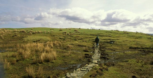
Lockdown could be an opportunity to reconnect with the country. Credit: Photofusion/John Morrison/Universal Images Group via Getty Images

Lockdown has turned my love of long-distance running into an obsession. The obsession is not with running, though. It’s with the psychogeography of the English countryside.
Psychogeography was invented by the 1950s Lettrists, a kind of French version of the Beat movement. The Lettrists spent most of their time getting drunk and wandering round Paris, during which time they came up with the theory that cities carry emotive force-fields. These, they posited, vary from location to location, and can be most easily detected by bumbling aimlessly about without trying to get to anywhere in particular.
Cynics might call this an elaborate way of justifying spending your Metro fare on beer and getting lost on the walk home. But the idea that built environments have something akin to emotional content has proved persistent, and regularly reappears in arty protests against (for example) urban gentrification or advertising.
Our rural landscape, as I have discovered, is every bit as much a built environment as Montmartre or the City of London. If you stroll through it while imagining you’re in some kind of pristine ‘natural world’, you won’t experience much beyond an uncomfortable sense of something pure that’s been ruined by human depredations. But if you let your mind wander like a drunken 1950s art-hobo, what emerges are murmurs of a conversation that has been going on for some 800,000 years.
Even those parts of the countryside we think of as untouched have been cultivated for millennia. Archaeological evidence shows the apparently wild, empty vistas of Dartmoor were first created by humans clearing ancient forest for hunting. The land there has been grazed for 4,000 years.
To hear the conversation, take to the footpaths. Such byways riddle the English landscape, in merry contrast to the ‘PRIVATE PROPERTY’ signs and anti-traveller bollards that sprout at estate gates and farm tracks. The very nature of footpaths evokes the past: their existence imposes a duty on landowners to keep them open, an echo of feudal landowners’ obligations to the peasantry. Even the term ‘right of way’ hints at a conception of ‘rights’ that predates our modern ‘universal human’ variety. And when travelling these ancient routes, even in the most unremarkable part of the country, you can still catch glimpses of old England out of the corner of your eye.
I don’t mean you’ll find the hay-wains and apple-cheeked peasants of some chocolate-box Turneresque vista. The modern world is as visible in the countryside as the cities, if you’re looking for it: wind turbines, the bluish-green tint of nitrogen-fertilised wheat, ancient hedgerows unlaid for a century and gradually morphing into trees. But the layers are still there. Bluebells along a footpath will give clues to old woodland now grubbed up for agriculture, while a byway between two villages mentioned in the Domesday Book is sure to be as old as those villages.
These ancient habits of movement exert a gravity of their own, in defiance of our modern determination to gallop full-tilt at the future. Even repackaged in progressive colours as ‘access to nature’, well-used footpaths represent a Burkean understanding of conservatism, written into the landscape itself. Most of them are unpaved, many are un-signed, and they stay visible because people walk them, trampling cowslips and nettles back, re-carving old routes across farmland.
One of my favourite local runs cuts diagonally across a field that’s usually planted with wheat. The farmer ploughs it up twice a year, and every time that happens, within half a day the path is trodden back in again. Footpaths exist as much in human memory and habit as in the soil.
And indeed, the slippage between the words ‘habitual’, ‘habitat’ and ‘habitation’ richly suggests the small-c conservatism of all the ordinary people, unnamed in history books, whose feet trod (and still tread) our footpaths into the soil. In turn these habits create us: the ‘peasant poet’ John Clare, for example, was driven insane when the Enclosure Acts so annihilated his habitual ways of moving round his locality that he could no longer find his mental bearings.
Once memorialised in culture and topography, habits of living take a long time to change. On one route, I pass a manor house whose layout is astonishingly medieval. Unlike the landscaped estates created in the 18th and 19th centuries, by mercantile grandees keen to distance themselves from the peasantry, here the L-shaped great house has no formal garden. Instead it abuts the home farm, while just inside the house gates sits a tiny Norman chapel that was still — until the lockdown — in public use every Sunday.
Beyond the manor, I run for miles without seeing a paved road, or another person, before cresting a rise to see two figures on horseback crawling ant-like across my field of vision two hillsides away, near the Norman spire. Abruptly I realise they are not crawling at all, but moving at a gallop. The distance I’ve run suddenly seems enormous, and I find myself thinking about that favourite post-liberal phrase, ‘human-scale’.
Geoffrey Chaucer worried in Troilus and Criseyde about being misunderstood, because of the ‘so great diuersity/In English and in writing of our tongue’. When he was writing, the denizens of two adjacent counties might travel so rarely they’d struggle to understand each other’s dialects. I find this much easier to imagine, having experienced the time and effort needed to travel 15 miles on foot via unpaved roads.
Despite such daydreams, I don’t live at ‘human scale’ in this sense. I’m an urban refugee, new to this area by local standards, and far more a product of the world of abstractions than the kind of rootedness I’m in danger of romanticising here. I consume the local landscape for fitness and thinking-time, not to earn a living. But as my feet make their small contribution to the latest rewriting of ancient paths, so it feels like the paths return the favour, over-writing me as well with the place’s story.
Opened, enclosed, lost or half-remembered, England’s old ways mark out a shared map of landscape-knowledge whose contours are cumulatively as old as human life on these islands, and which is constantly written and re-written by usage. Some of the paths local to me are Roman, or even Iron or Bronze Age. When running them, I find myself wondering: how much has the skyline changed over those millennia? What do I see today that those ancient Britons didn’t? What would they miss or marvel at?
In those moments, for a split second I glimpse not the world turning, but the ages themselves. Then I turn and pound down the hill, past fields that have just been sold off to build a new commuter town. I wonder whether the new town’s streets will incorporate the ancient footpaths, or whether some central planner will finally scribble them out.
The geography of Britain is an ongoing push-pull between grand schemes (such as new towns) that rewrite the landscape itself, and the ‘little people’, poets or not, whose lives flow round such projects. The balance of power flows back and forth between abstract schemes and habitual experience: on the one hand land enclosures, towns or quarries and on the other, footpaths and other old ways, which stubbornly persist.
Post-liberals have a tendency to idealise the cultural and the collective, with its moral analogue, the ‘common good’, and to have little positive to say about the world of abstractions, modernisers and ‘progress’. But as I’ve delved into my local byways, the rural psychogeography they reveal is a dialogue between the abstract and the emergent, the Whig and the Tory accounts of England. Not wholly human, but everywhere humanised.
Now the Wilderness Drone Police have packed up their rambler-shaming cameras, celebrate the easing of crisis with a dérive through England’s profoundly cultivated natural world. If you do so slowly enough, the footpaths will tell you stories.


Join the discussion
Join like minded readers that support our journalism by becoming a paid subscriber
To join the discussion in the comments, become a paid subscriber.
Join like minded readers that support our journalism, read unlimited articles and enjoy other subscriber-only benefits.
Subscribe