


Credit: Julien M. Hekimian/Getty Images


To understand flyover France you need to get grips with the following: one side of a hexagon; an empty diagonal; a rusty belt; and a blue banana.
Don’t worry, all will become clear; but first we must start in America.
The red state blueprint
The original ‘Flyover country’ is, of course, American. It refers to that great swathe of the USA between the east and west coasts – or, to be more exact, between the ‘Bos-Wash’ corridor (Boston to Washington) and the big coastal cities of California.
As a phrase it’s surprisingly recent. The earliest references date back to 1980 – i.e. well after California’s establishment as a major economic and cultural centre and well into the era of commercial air travel.[1. Gabe Bullard, ‘The surprising origin of the phrase ‘flyover country’, National Geographic, 14 March 2016] Perhaps it had to wait for a crucial realignment in America’s political geography.
Before the Kennedy and Nixon eras the big divide on the electoral map[2. For the US electoral maps back to 1789 see ‘Historical Presidential elections’, 270towin.com,] was, broadly, between the Republican North and the Democrat South. The social upheavals of the 60s onward turned things upside down – North and South switching allegiances. By the dawn of the 21st century a new geography was fully established. The Democrats took the east coast down to Virginia plus the whole of the west coast; the Republicans holding the South and most of inland America – a.k.a. flyover country, ‘red state America’, ‘Jesusland’ etc.
Donald Trump made the division even starker by breaking through into the Great Lakes region, previously a political extension of the east coast. His victory underlined the cultural estrangement of the two Americas. The flyover image of a jet-set bi-coastal elite literally looking down on the heartland has become more potent than ever.
With the rise of populism across the western world, analysts are busy mapping out flyover country in other countries. Which brings us back to France.
Six sides of France
As Nabila Ramdani explained in a piece for UnHerd in March, support for the hard right Front National follows a distinct geographical pattern.
France is roughly hexagon shaped – indeed the French refer to their homeland as L’Hexagone. Of the six sides, three are defined by coastlines: along the English Channel (La Manche); the Atlantic; and the Mediterranean. The other three sides are made up of land borders: with Spain in the south; with Italy, Switzerland and Germany in the east; and with some more of Germany, Luxembourg and Belgium in the north.
The Front has two strongholds: a narrow strip along the Med and a much broader band of territory delimited by the northern land border.[4. Gregor Aisch et al, ‘How France voted’, New York Times, 7 May 2017] It’s the second and larger of these two territories that is France’s flyover country.
British holiday makers may have driven through it, however. A road trip from Calais to the Rhine would put nearly 400 miles on the clock. Until you get the Vosges mountains, most of that is pretty flat – and leaves a lingering note of cabbage field.
The rust belt and the desert
As well as a whole lot of agriculture this is, or rather was, France’s industrial heartland – a place of coal fields, steel towns and manufacturing centres. This is the French rust belt, and an obvious conclusion is that the surge in support for the Front National is a reaction against industrial decline. Certainly, that’s part of the story, but not the whole of it.
As Henry Olsen explains elsewhere in this series, there’s a lot more to America’s flyover country than post-industrial cities like Pittsburgh and Detroit. Similarly, there’s a lot more to French flyover country than places like Lille and Metz. As with the American heartland, the overwhelming sense one has of north eastern France is of space and disconnection. Indeed, France east of Paris and up to the northern border represents one extreme of la diagonale du vide or the ‘empty diagonal’– an area of low population density that stretches from the north east of France to the south west. This is the heart of the heart of western Europe, and yet so depopulated that the geographer Jean-Francois Gravier called it the ‘French desert’.[6. Jean-Francois Gravier, Paris and the French desert, Portulan, Paris, 1947]
Gravier opposed the concentration of political and economic power in Paris and the surrounding Ile-de-France region – the result of which, he said, was to suck people and investment out of the rest of the country.
There are many in Britain who feel the same about ‘L’Ile d’Angleterre’ i.e. London and its surrounding region. However, there is a subtle though important difference between the French and British situations – which is the latter doesn’t have a flyover country. The UK certainly has its share of economically and culturally disconnected communities, but, unlike America, they’re not hemmed-in between comparable centres of gravity on either side of the country. There is no looked-down-upon heartland – just London versus everyone else.
The Blue Banana
France, however, does have a counterweight to Paris. It’s not any other French city (none of which are big enough), but a very different feature of human geography – the so-called ‘Blue Banana’.[7. Frank Jacobs, ‘The Blue Banana – the true heart of Europe’, Big Think]
This refers to a boomerang-shaped concentration of people and economic activity that s tarts in the densely populated low countries, (think Rotterdam, Amsterdam, Brussels, Luxembourg); it then angles around the Franco-German border (taking in the Saarland, the Ruhr and southern Germany), before coming to a mountainous conclusion in Switzerland.[8. A longer version of the banana starts in London (or even Manchester) and ends somewhere around Milan]
This arc of prosperity is the continent’s economic backbone; the old frontier of the western Roman Empire; the fruitful interface between latin and teutonic Europe.
Here’s another way of looking at it. First, get yourself a dinner plate. Then put an apple at the centre of it and a banana along one edge. Congratulations, you’ve made yourself a map. The apple represents Paris; the banana is the Blue Banana; and the gap between the two is French flyover country.
The people who live there can look up and watch their rulers wing their way from Paris to Brussels, Frankfurt or Zurich, but on the ground, there’s nothing much going on. De-industrialised and or depopulated, investment and people are pulled inward to Paris or outward to Europe’s economic backbone. It is in this trough between two zones of vitality that the Front National prospers.
Consumed by history
I make it sound like a wasteland, but much it of it is lovely. I know one part of it, the Department of the Meuse, very well, because that is where my mother’s family is from. The Chef-lieu of the department, i.e. the county town, is Bar-le-Duc – the upper part of which is the Ville-Haute, a minor masterpiece of renaissance architecture. It’s a place consumed by its history – on occasion, literally so, when gardens subside into long-forgotten cellars, tunnels and other remnants of the town’s medieval incarnation.
In recent decades, a lot of money has been spent doing the town up – for instance, by sand-blasting centuries of soot from every listed building (which, in the Ville-Haute, is almost all of them). With doors and shutters smartly painted in a palette of pleasing colours, it’s an off-the-beaten-track gem.
And yet a spacious townhouse can be yours for the price of pokey flat in an English commuter town. Some properties stay on the market for years unable to find buyers. On the main square there’s a terrace of four-storey sandstone houses that stands permanently empty – windows broken, balconies rusting.
Where the fabric of the Ville-Haute has received the care it deserves much of it is financed by the state – either directly, through grants and regeneration schemes, or indirectly through the salaries and pensions of the teachers, doctors, lawyers and civil servants who live there.
Employment prospects in the town are bolstered by France’s generously-funded public sector, but, in the rest of the department, joblessness is well above the national average – if not quite as bad as the worst unemployment blackspots elsewhere in French flyover country.[8. Jeremy Smith, ‘Mapping France – the link between unemployment, GDP and voting Front National’, Prime, 10 June 2014] Across the whole Lorraine region, of which the Meuse is a part, GDP per head is among the lowest in France and on a par with the very poorest parts of the UK.[9. ‘2015 GDP per capita in 276 EU regions’, Eurostat, 30 March 2017] Over the last fifty years the population of the Meuse has dropped while that of France has increased – and is less that 60 per cent of what it was at its 19th century height.
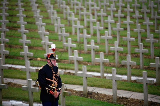
Mort pour la France
Heading north out of Bar-le-Duc is the Voie Sacrée (the Sacred Way) – the road to Verdun. In the First World War it was this vital artery that kept the French frontline supplied with fresh troops; and brought back the fallen. It is around Verdun that one finds the most depopulated parts of the Department: several villages that were so damaged by shelling that they were never rebuilt. They still exist as ‘communes’ (the most local administrative tier), but with official populations of precisely zero. The French call them “mort pour la France” – they died for France.
The ghost villages remind us that flyover France is contested territory. Millions have died on its soil to make it, and keep it, French. It seems to me that in this country, as in others, populism thrives on old battlegrounds and invasion routes, behind uncertain borders and shifting frontiers… Oh, and beyond the big cities, of course.
Writing in the New York Times, Philip Auerswald and Joon Yun quote a truly remarkable statistic, which is that across every continent bar Africa, the entirety of the world’s population increase is taking place within the 500 biggest cities. Outside of these cities the global population is now shrinking (again, Africa excepted).[10. Philip Auerswald and Joon Yun, ‘As population growth slows, populism surges’, New York Times, 22 May 2018]
It’s not that big cities are especially fertile places – quite the opposite, in fact.[11. Ali Modarres and Joel Kotkin, ‘The childless city, City Journal, Summer 2013] Rather they grow through absorption. If flyover populations see the metropolitan influence as dehumanising, it’s because it’s literally true.
Geography matters
For the liberal elites there’s an obvious answer to depopulation: immigration. They see how immigrants contribute to the constant churn and reinvention of metropolitan economies and assume that the same would be true elsewhere. But it should be clear by now that geography matters. The capacity of a global city to benefit from globalisation doesn’t extend out in all directions. As Paul Embery has pointed out, it doesn’t even extend across the whole of the metropolis – let alone the hinterlands beyond it.
After all, there’s a reason why the elites fly over flyover country.
Peter Franklin is Associate Editor of UnHerd. He was previously a policy advisor and speechwriter on environmental and social issues.
 peterfranklin_
Join the discussion
Join like minded readers that support our journalism by becoming a paid subscriber
To join the discussion in the comments, become a paid subscriber.
Join like minded readers that support our journalism, read unlimited articles and enjoy other subscriber-only benefits.
Subscribe